WMTS (Beispiel JPEG)
URL: https://mapsneu.wien.gv.at/wmts/lb1956/grau/google3857/12/1419/2234.jpeg
Dataset description:
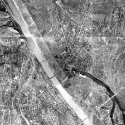
Der Luftbildplan von Wien aus dem Jahr 1956 deckt das gesamte Wiener Stadtgebiet in einer Auflösung von 50 Zentimeter ab. Die Luftbildbefliegung fand im April 1956 statt....
Source: Luftbildplan 1956 Wien
Additional Information
| Field | Value |
|---|---|
| Data last updated | unknown |
| Metadata last updated | November 5, 2025 |
| Created | unknown |
| Format | JPEG |
| License | No License Provided |
| Created | 6 months ago |
| Issued | 10 years ago |
| Media type | image/jpeg |
| Modified | 2 years ago |
| Uri | https://www.data.gv.at/katalog/distributions/d625d501-79ba-4df4-bdc6-81dae2afbb41 |
| Access url | https://mapsneu.wien.gv.at/wmts/lb1956/grau/google3857/12/1419/2234.jpeg |
| Datastore active | False |
| Datastore contains all records of source file | False |
| Distribution ref | https://www.data.gv.at/katalog/distributions/d625d501-79ba-4df4-bdc6-81dae2afbb41 |
| Has views | True |
| Id | 3d5bd734-6bbe-4bbd-baa0-55b3fce6cf53 |
| License | https://creativecommons.org/licenses/by/4.0/ |
| Package id | da850d04-007a-4b80-ad5b-619b332df110 |
| Position | 0 |
| State | active |